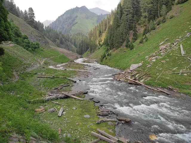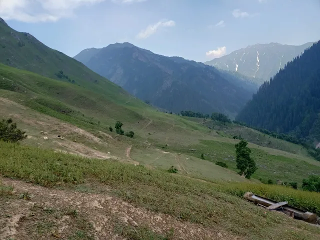
Neelum Valley Azad Kashmir is rich in natural beauty granted pastures, forests and wildlife. There are numerous places for tourism in Neelum Valley. Today I am going to give you relevant information about areas where very few tourists have visited. Yes, this beautiful hidden valley is known as As Gagai (گگئی).
As Gagai (گگئی) valley is the largest pasture of Gurez Valley, situated at the end of Neelum Valley, at an altitude of 6000 to 13000 feet above sea level. This pasture is surrounded by two major waterways, smaller one is (Dadgai Nallah (ددگئی نالہ)) and the other major as Gagai (گگئی نالہ) Nallah.
Qamri Astor is in the east, Taobat is in the west, Line of Control and Occupied Jammu and Kashmir are in the south-east, while Gujjar Nala Phulawai and Riyat Astor (ریاٹ استور) are in the north.
In winter season it is seen around Six to eight feet of snow falls here, throughout the season land is covered with white snow that causes the blockage of roads and trails.
In summer, the local people of Dudhniyal (دودھنیال), Sharda and Gurez Valley takes their cattle, many Bakarwals (Nomads - بکروال) bring cattle from different areas of Azad Kashmir and Pakistan and remains in the area from May to the end of September.
How to plan a trip to Gagai?

Dadgai Nallah (ددگئی نالہ) is a beautiful grazing land. Among the famous small pastures here are Ziyan (زیان), Rata Pani (رتا پانی) and Musitaan wali Behks (مسیتاں والی بیکیں). This is the reason for the fame of Rata Pani (رتا پانی), the water is transparent, but the color of the soil under this water is completely red. This whole area is very beautiful. In front of it lies the area of Zayan (Occupied Kashmir) which is included in the Gurez Valley (گریز ویلی) on other side of Kashmir. (Pasture here is called “Behkin بیکیں” in local language)

Then a journey will be headed to Big Gagai in the eastern direction. If you reach Taobat using your personal vehicle then you need to park the car in Taobat and only choose the necessary items to be carried along with you. In this channel first comes the Behks of Taobat community followed by the Behks of Parma community (پارما برادری Hindko speaking community). Here on the way Shakargarh Nallah (شکر گڑھ نالا) diverges in the southern direction.
The last upland area of Shakargarh Nallah (شکر گڑھ نالا) meets Riat and Gujjar Nala (ریاٹ اور گجر نالہ). Most of the Bakarwals (Nomads بکروال) go to this canal with their cattle in summer. In the same way, at the beginning of Shakargarh Nala (شکرگڑھ نالہ), there is an ancient graveyard of Bakarwals (Nomads بکروال). In summer, if someone from the Bakarwal (بکروال) community dies, they are buried in this cemetery.
The next way to cross the Shakargarh Nala (شکرگڑھ نالہ) and continue journey straight ahead to the east. On the way ahead, there are people belonging to Malik community.

Next from here are the “Chhoti Khoriyas” (چھوٹی کھوڑیاں) and “Bari Khoriyas” (بڑی کھوڑیاں) behk. On the way, there are beautiful waterfalls, plains, snowdrifts and roaring rivers. And after four hours of travel, it takes you to starting area of Biloraksi “Nala” (بلورکسی نالہ). People also take goods and cattle in Baluraksi Nala (بلورکسی نالہ). The area is rich in precious stones and herbs.
Next beautiful location is to reach Jalkhat or jalkhad (جل کھٹ), the most beautiful pasture (behk) of this area by evening and enjoy the beautiful morning and evening scenery of this area. You can go through a difficult hilly terrain and reach Jalkhat in about half an hour. The temporary residents here are very hospitable. Here you can spend the night on fire, entertain yourself with desi curry, curd, ghee and corn bread. Short but the taste of such country food may not be that of five-star hotels.
In Jalkhat (جل کھٹ) there were camps of hundreds of the people who had gone from Murnat (مرناٹ), Phulawi (پھولاوئی) and Dudhniyal (دودھنیال). There people are very busy with livestock. People along with livestock extract herbs from the hilly area for livelihood which are sold locally at reasonable prices. Its legal and illegal drainage and delivery is a separate topic. At the time of dawn, elderly men and women wake up and after praying, prepare breakfast and then manage to herd the livestock. In the evening, milk is extracted from the udders of the animals after returning the cattle. Here people use lassi (لسی), milk, tea, curry, greens and rice more for food and drink. Most of the food is indigenous and pure.

Along with herbs, precious stones are present in this area. Some people take leases here and mine stones, including more tourmaline, mica and sapphire stones. Next to Jalkhat comes the areas of Larrian (لڑیاں) and Sarat (سراٹ), from here comes the area of Qamri District Diamar (قمری ضلع دیامر). Most of the time in summers, the people of Qamri travel along this footpath, they also do light business with the local people. Next to Qamri comes Mani Murg (منی مرگ) and then Devasai (دیوسائی) regions. That is why this region is a very important region along with being beautiful.
These areas are very beautiful and rich in innumerable natural resources, due to the negligence of the government, the local people are suffering in various problems in which three problems are prominent, education, health and employment. In such large areas where thousands of people live in summer, there is no facility in the name of education and health.
The government should at least establish a small rural health center (hospital) in the base camp Taobat of this area so that these people can get timely medical facilities. Improvement is possible if the government takes revolutionary steps in the mineral resources and tourism sector to provide employment.


